
Page 175 - THE ONTARIO CURRICULUM, GRADES 9 AND 10 | Canadian and World Studies
P. 175
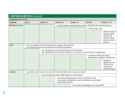
       1. MAP AND GLOBE SKILLS (continued)
           A. Map Elements (continued)
     Grades 11–12
  • uses intermediate cardinal compass points (i .e ., NE, NW, SE, SW) to provide direction
    • is able to orient a map
    • makesconnections between degree
cardinal compass points to provide bearings and direction
 • uses non-standard units of measurement (e .g ., footprints, blocks, houses)
• uses relative distance (e .g ., near, far, further) to describe measurement
  • uses standard units (e .g ., metre, kilometre) to measure distance
• uses absolute distance (e .g ., measures distance on a map, uses a measuring tool on a digital map)
  • uses large- to small-scale maps, as
appropriate, to investigate a specific area
    • determines
appropriate scale and intervals to communicate intended messages
 • uses relative location (e .g ., near, far, up, down) to describe the location of a person or object
   • locates hemispheres, poles, and the equator on a map or globe
 • uses latitude and longitude to locate something on a map or globe
• uses number and letter grids to locate something on a map
• understands time zones
  • uses locational technologies (e .g ., compass, GPS)
  Grade 9
         Grades 7–8
      Grades 4–6
          Grades 2–3
        Grade 1
         CATEGORY
   Direction (continued)
    Scale
    Location
  173
